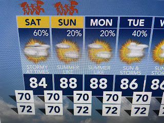
With the center of the upper high remaining well down over the Gulf, expect more storms over night & again on Saturday. The black dashed lines are the boundaries with stalled front near us.
Note how the 70+ dew points (very deep moisture) have surged over us giving the air a tropical feel again. Here's what the model is forecasting for tomorrow.
Note, the bottom view is the VIPIR model that is more bullish for afternoon storms on Saturday. It's difficult to time these disturbances as they travel across Mexico into Texas.
Tomorrow's feature is already triggering storms SW of Dallas. It's not like we can follow a strong cold front marching our way. That just won't happen here until September.
In the short term, it appears this afternoon's heaviest storms are marching across the far North Shore into Mississippi. That could be reversed tomorrow IF the models are correct.
Sunday does look to see fewer/lower rain chances, but each day into next week will see spotty showers around. Best get used to it as it's called Summer in Da South! Enjoy your weekend & stay tuned!


No comments:
Post a Comment