You can follow the radar swirl moving along the LA/AK border into Mississippi with a very pronounced bow echo often indicating strong winds. Under the clouds & rain, temps are in the 70s, while outside the rain areas, it's mid to upper 80s.
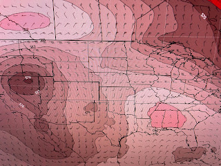
The tough that has been over the western states has evolved into several slow moving cut off upper lows. The graphic following the satellite view is this morning's upper air chart followed by the forecast for Saturday & Sunday mornings. Note now the low over Denver lifts into South Dakota with another forming along the NM/TX border. By Sunday, that pink reddish area over us is a weak upper high. IF that proves to be reality, we should see a drier & hotter weekend with few, if any, showers.
Today's surface map has no fronts around us so all the storms to the north are triggered by that disturbance moving into Mississippi.
Under the upper lows, it's quite chilly. The reason our rain chances won't go to zero this weekend can be found in the bottom dew point graphic. Deep tropical moisture covers Texas, Louisiana into MS/GA. Since our highs are now well up into the 80s, it won't take much to bubble up a spotty storm. But as the upper high builds in this weekend, rain chances go down. Keep up on the storms to our north for the next several hours. Stay tuned!


No comments:
Post a Comment