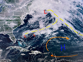
I've drawn the upper air flow on top of the satellite views. The top shows low pressure off both coast with a strong high centered up over Canada west of Winnipeg. The next view has a deep low off the East Coast that is driving down some very chilly air over the Northeast. Normally, that cool air is clear & clear, but not this year as we have numerous wildfires blowing smoke plumes across Indiana, Michigan, Ohio & Pennsylvania. Boston is 59 with showers...burr! So where is our Summer Bermuda High?
Note on the surface map, there is no large Bermuda High/Atlantic ridge. Instead we have a bunch of weak surface features/boundaries. The above normal activity is bringing cooler relief to many while only a few have 90+ heat.
South Louisiana is seeing more action than north LA. Locally, you can see who's getting wet as temps have fallen into the 70s. The T-Storms north of Lake P. have prompted warnings so pay attention up north. One thing I noticed today is the increased in the ESE winds. The buoy at Shell Beach has winds 15-25 mph!
Until the upper air pattern changes, I don't see any major changes here so expect our daily showers. Some might say that it's "typical summertime", but now you know better! Finally...
My former co-worker Howard Bernstein (1989-94 at Ch. 8) was storm chasing last week in west Texas. He and 2 others were rewarded with this tornado sighting. The tornado was about one mile from them and touched down in an area with no building or people. As it dissipated, it took on the custom look of a rope. I'll have more pictures from Howard tomorrow. Yeah, yeah, I know NHC is following a thing near the Azores. Let them have their fun! Stay tuned!


No comments:
Post a Comment