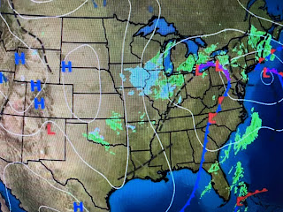
Note the surface wind direction has become more westerly and that should limit the warmer lake effect to Orleans, St. Bernard & Plaquemine Parishes. Here's the computer guidance that Amber Wheeler showed us at 4 PM.
The colder air surged down into the Gulf as our clouds finally pulled to the north & east, but not by much.
There remains a cut off upper low across the eastern states making for chilly, by not cold conditions for December. The main jet stream coming in to the West coast is diverted up and over this upper low keeping the super cold air (29-30 below) up over northern Canada & Alaska.
In the short term we stay chilly with a slow warm up ahead of the next storm after midnight on New Years Eve.
Monday looks rainy with another system over the Gulf on Wednesday giving another shot of moisture. This is a common pattern during an El Nino year. Our recent rains have really improved the drought conditions across our state.
The top view is from the first week in December with the bottom view issued today. Since we're not in the growing season, we really don't need more rainfall. However, our dry pattern from this summer & fall is gone so expect a wetter pattern as we head towards spring.. Finally, here are some sunset pictures sent to me over recent days.
The top is from my youngest son (Justin) in Oklahoma City while the bottom is from Becky Steppe. In both views, the sun has set below the horizon with its rays illuminating the base of the clouds. You see any interesting cloud pics, send them to me. Stay tuned!


No comments:
Post a Comment