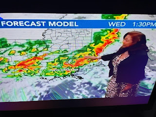
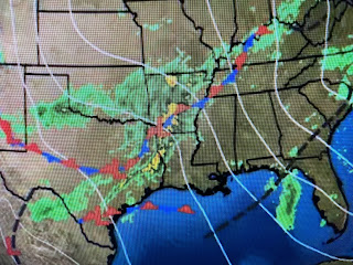
The northerly cold flow over us has shifted back to an upper SW flow allowing warmer air to overspread most of the eastern states. In that upper SW flow are minor disturbances that trigger waves of heavy rainfall. You can see 3 such waves, especially on the radar views.
The first wave is exiting Michigan into Canada with the second moving through Arkansas into Louisiana. The third is showing up back over Arizona & New Mexico. The problem for us MIGHT happen IF these rain bands align themselves in a SW to NE orientation. That creates a "training effect" of storms. Nicondra showed us the current model timing.
It appears RIGHT NOW, the heavier rainfall will be to the north & west of the South Shore. But that could easily change. Bottom line, the next several days we need to keep up on changing weather conditions.
I trust you see the reasoning for FOX 8 calling for a FIRST ALERT?!!! Look at the complicated surface weather map!
It has warmed enough that snow & ice are no longer a problem. However, see the near 70 dew points over south Texas. That's very juicy air that is spreading our way making for "very efficient" rainfall rates.
Another cold front finally arrives Saturday morning ending our rain threat. The air behind that front is of Pacific origin so it'll be cooler & not colder. Another thing to remember, 100% rain chances does NOT mean it'll rain 100% of the time. We should see some dry hours during this next 3-4 day wet stretch. Have your FOX 8 Weather App ready to alert you to any warnings. Stay tuned!


No comments:
Post a Comment