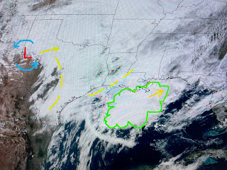
Ok, so what happened to all the heavy rains that computer models predicted for us last night? Clearly, the models were wrong. But why? Satellite views have shown a persistent cluster of storms south of the Louisiana coast. It appears to me that feature has cut off/limited the northward flow/movement of rain into our state. However, see how rain is breaking out back to our west and around the upper low. As that low streaks to our east overnight, it will drag a cold front reaching us around daybreak tomorrow.
There is a strong probability that a squall line will be ahead of the front with the heaviest storms passing SE LA/MS between 4-8 AM. SPC has a level 2 risk for severe storms well to our east, but don't be surprised to be awakened by the noise of these storms as they pass through.
It's chilly north of the stalled boundary, but it's not the frigid air of last week. Note the temps in Texas are in the 50s and not the 30s. Record highs topped 80 in many cities along the East Coast.
So the 60% chance for rain tomorrow will be in the early morning. So nice to see those sun icons after that! That 70 degree high on Saturday will be before dawn as temps fall into the 50s rebounding into the 60s with afternoon sunshine.
It appears there is no heavy rain threat this evening. I'm heading out to an early dinner. The main rain threat arrives after midnight through 6-8 AM. Watch FOX 8 to see the latest model timing. Enjoy your sunny weekend & stay tuned!


No comments:
Post a Comment