For most of us, just being in Hurricane Season brings our anxiety levels up. But do we really need this "Alert/Warning" 3 months ahead of time? Especially when buried deep in the newspaper article (bottom graphic) is the nugget that it doesn't matter for Louisiana. So why bother? Of what value is it to make us nervous before we need to be? Simple answer is headlines drive viewership. I don't mind the headline several weeks ago about the 2024 hurricane season.
That story provided useful information, although I don't really agree with it. I believe that "Less is More" and too much information on one graphic can lead to confusion. Unfortunately, NHC has received pressure from NOAA (based on research from "Social Scientists") to improve on their communication skills. Super Storm Sandy back in 2012 surprised/angered many folks so our government felt changes needed to be made. Alas, I've stressed the importance of following the center line track to make sure you stay out of the hurricane's eyewall. Small changes can make a huge difference as we saw in Hurricane Ida's jog to the east at landfall.
So what has NHC done because of pressure from "Social Scientists"? They removed the centerline track because "they don't want people to focus on the forecast track"! Duh! Now they are going to load the warnings on the "Cone Of Error/Uncertainty". Gosh, I can just see Joe & Mary Beercan looking at that graphic and saying, "Geez, isn't it pretty. What does it mean? I'm glad I'm retired!
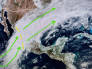
Weather-Wise, we are stuck in an upper air pattern typical of an El Nino Winter. In fact, the moisture today is coming not only from the Gulf, but from deep in the Tropical Pacific. Changes are coming for this weekend that will take away the clouds and showers and bring back the Winter cold. Let me explain. The upper pattern has been in an "Omega Block" (High between 2 lows) that is driving very mild air into Alaska (very few below zero readings) while displacing cold air down into the lower 48.
What we don't want to see is for an East Coast trough that will result in freezing air down to the Northern Gulf coasts. There will be a dip over the East, but NOT a Polar Vortex.
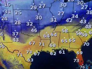
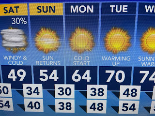
The coldest air in weeks is pouring southward out of Canada and will arrive here before daybreak on Saturday. It will be back to heavy coats for this weekend with a light freeze for the North Shore on Sunday & Monday mornings. The South Shore will be near freezing so I will bring some of my potted plants back inside my heated He-Shed tomorrow morning as I want them to get some rain tonight.
Most of the eastern states are cloud covered & ugly with a fast moving "clipper" dropping significant snow (3-5"+) from Missouri into Ohio. This system is heading for the big cities of the Northeast tomorrow.
There is even a band of "thunder snow" south of St. Louis into Illinois. Alas, we're too warm for any of the white stuff.
As you can see, Monday morning will be the coldest as winds decrease allowing for widespread frost BOTH sides of Lake Pontchartrain. A look at our climate records shows we still are in the time of the year when freeze can happen.
So I am ALERTING & WARNING all my fellow gardeners, be prepared to protect your tropical plants this weekend. There is a real reason to be anxious for them! Stay tuned!


No comments:
Post a Comment