The hatching indicates the potential for large, long tracked tornadoes. Even The Weather Channel has one of their highest TORCON (Tornado Condition) Indexes ever with a 9!
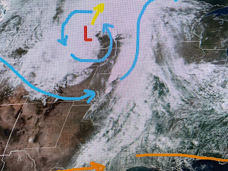
If you look at the past severe climatology for May 6, the threat is almost exactly where it has been in the past. So what's happening to create this PDS? There is a strong upper disturbance lifting northward into Montana with a splitting of the jet streams farther to the south.
The second satellite view has the "dry line" that functions as a frontal boundary. The dew points (green contours) have 70+ (tropical feel) readings surging into Oklahoma along with 70 & 80+ surface temperatures. SPC issued a tornado watch for those areas at around 2 PM, BEFORE any storms formed!
Fortunately for us, none of that weather is coming our way. What we start to deal with here is HEAT. When will we reach our first 90 degree day? Nicondra showed us recent history on her noon broadcast.
Baton Rouge beat us to that number as locations farther away from the cooler Gulf waters are hotter. Typically our first 90 happens during the second or third weeks of May. This year might be a week early?
That cold front back over west Texas will struggle to head our way until later this week when the upper air flow has a pattern shift. The western trough will redevelop over the eastern states and that should push the front by us for Friday. The next questions are...will it stall out? & where?
Unfortunately, today's model runs have the front getting through us but stalling down over the northern Gulf. That could bring us several waves of rain over Mother's Day weekend. I'm going to wait another day or two before I buy into that scenario. Tomorrow's models might push it farther offshore leaving us with a great feel weekend. Stay tuned!


No comments:
Post a Comment