Memorial Day is also a day of parades and celebrations to honor those warriors. One of the nation's biggest 10 K races is called The BOLDER BOULDER run around the city of Boulder, Colorado. My oldest son (Rob) sent me these pics. Obviously it was a perfect day as the satellite view shows. The white is the snow on the higher mountaintops.
Not everyone enjoy such a nice day as the upper trough over the Rockies has shifted over the northern Plains and Great Lakes. Lots of folks needed umbrellas and jackets.
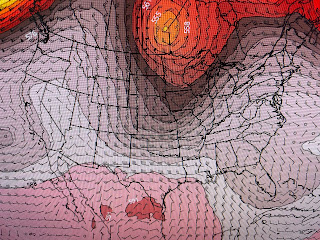
It's too late for us to get that colder air down south, but that trough is slowly pushing the upper heat dome farther to our south. It should mean slightly less hot temps and some spotty daytime storms for the next several days. The GFS model keeps the upper troughs coming not allowing the heat dome to build back. Under the Satellite view is the upper flow today.
After that, the graphics are valid for Wednesday, Friday Sunday, and next Tuesday. Hopefully that will mean we stay almost hot, but not flirting with record heat?
This week will not be our typical summertime pattern where we see tropical waves/moisture rotating westward around the Bermuda High/Atlantic Ridge. No signs of that happening yet.
With dew points near 80, our feels like temps (110) have reached the danger range. Be cautious doing outdoor activities during the middle of the day. My house had a brief shower between 1-2 PM.
I'm afraid our hopes for any more rain today are slim & none. Finally,
While all we hear about is the heat, found this article that the mainstream media won't show. The World is not on fire everywhere. Just trying to be fair & balanced! Stay tuned!


No comments:
Post a Comment