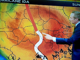
For those of you new to this blog post, or who didn't watch me during my 38 years on Ch. 8 in New Orleans, you may ask, "Why does he focus on the centerline track?" Simple answer is past experience. I visited many a major storm (Ivan, Katrina) areas after landfall and saw first hand that 1) avoid the EYEWALL as that's where the most destruction occurs, and 2) stay on the weaker side (typically to the left of centerline) and impacts are far less. A classic example was Hurricane Ida that blew up from a Cat. 2 to a 4 at landfall. Had Ida not taken a jog to the right, much of St. Charles & Jefferson Parishes would have been (like Orleans Parish) spared the worst of the damages. But that little jog of 25-30 miles brought the eyewall over them. Here's David Bernard pointing out the jog.
Ida took down one of my big water oaks destroying much of my backyard. Fortunately, the tree fell away from my house. But if you drove to the east into Orleans Parish, the damage was much less. Sure they had some impacts, but avoid the eyewall & you survive the worst damages. hence my focus on that centerline that has once again drifted farther to the east. Let's begin with the Satellite views.
Clearly, this storm is getting better organized and Recon confirms surface pressures are falling. Winds will respond later today. The infrared color view shows the northside is lacking storms around the center (white arrow).
Radar views agree with the bright/heavier colors wrapping around the western and southern sides. That will change later today as NHC is still forecasting intensification to at least a Cat. 1 Hurricane. If you just focused on the cone, you would not see the subtle shifting to the east that NHC has been doing for days.
Even adding in that centerline track on the wide view doesn't show the shift. But I go to the NHC interactive graphic and zoom in to the landfall. Here's what's happened since last night. The 10 pm advisory (top map) had the centerline west of Matagorda Bay.
The above graphics show where the greatest impacts are now and where they will go on Monday. For SE LA/MS, impacts will be minor tomorrow with the higher heavy rain impacts coming Tuesday & Wednesday as what's left of Beryl pulls away to the NE.
That will only happen IF any of Beryl's rain bands rotate over us.
One such outer band extends over SE Texas & SW Louisiana. Texas will receive the greatest/damaging impacts from Beryl. We dodged this one Gang. Pray for friends & family to our west. Since I have an afternoon function, I may not post until late this evening. The next NHC advisory(4 PM) will not show any dramatic track changes but might make Beryl a Hurricane once again. Stay tuned!


No comments:
Post a Comment