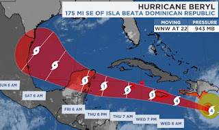
As I sit here going over the various graphics that all of you can easily view on the internet, I wonder what extra information/nuggets that I might give you. I know you want to know..."but what does Bob think?" I'm humbled by your trust so I'll try to add "stuff" that the other channels won't give you. Let's begin with the basics that each station will provide. Hurricane Beryl has weakened slightly back down to a strong Cat. 4 (155 mph) and is following a track on the north side of NHC's cone of error. This has increased the danger to Jamaica & the Cayman Islands.
The bottom graphic gives you an idea of what land areas are at risk from Beryl. Why has the risks increased for Jamaica? If you have followed previous blog posts, you know I track the centerline to see which way NHC/models are trending. Look how that has changed in the past 2 days.
That 50-60 mile nudge to the north now means the eyewall will pass right over Jamaica and, as this graphic from The Weather Channel proves, is a recent rare event.
I vacationed on the Caymans 2 years after Hurricane Ivan and there was still a lot of damage. Jamaica at least has elevation and folks can get away from the coast. With modern communications, no one should be surprised by what's about to happen from a Cat. 4 hurricane.
Beryl's satellite structure is beginning to show signs of increasing upper wind shear. Still, she's not weakening fast enough. You've seen the NHC's forecast track that now hint south Texas needs to pay attention.
So what will I be looking for? Follow that centerline. IF Beryl goes on the north side of the cone of error, we will need to start paying closer attention. We don't want Beryl to miss the Yucatan (Cancun ^ Cozumel does!) and not weaken as it gets into the Gulf. But what about our blocking upper heat dome?
IF you believe in models, the heat dome weakens and shifts to our east with time. The top graphic was valid this AM.
The second is valid Thursday AM, followed by Saturday AM & The bottom valid on Monday. You can see the heat dome shifts away to our east allowing whatever is left of Beryl a path to the north. RIGHT NOW, it appears that turn would be too late to impact SE LA/MS. But Texas could have issues.
The Spaghetti models indicate that. So I suggest to you...follow that centerline track to see IF Beryl goes right over Jamaica or just to its north. We have many days to watch this beast. Locally, it's all about boundaries & the heat.
Look at those 50-60 dew points over the Carolinas & Georgia. That's good feel air. Not here.
Many spots flirted with 100 again, but slightly higher rain chances tomorrow should keeps us in the low to mid 90s.
Hopefully I provided some food for thought as you watch your favorite weathercaster. My goal was to always give extra value to the information available on the internet. My immediate concern is to pray for Jamaica & Grand Cayman. Stay tuned!


.jpg)

No comments:
Post a Comment