I remember reading those words issued by the Slidell office of NWS before Katrina struck. Those were words of wisdom that I believed saved thousands of lives. Indeed, NOLA was brought to her knees and it took weeks just to restore power and months to get basic services back. Total recovery took years and I'm afraid Florida's West Coast will suffer the same fate. Hurricane Milton, like Katrina a Category 5, is expected to weaken back to a Cat. 3 before landfall on Wednesday. But remember, a decrease in winds doesn't mean less a storm surge. Katrina's surge was 28-31 feet along the Mississippi Coast, which is still the record for Gulf Coast states. Here's the 4 PM advisory from NHC.
Nothing has changed regarding the centerline track and Milton's peak winds are now 180 mph! His satellite structure is a classic "donut hole" with a small eye. The Recon Pilot noted birds could be seen flying around the small center. They got trapped when Milton went through a rapid intensification.
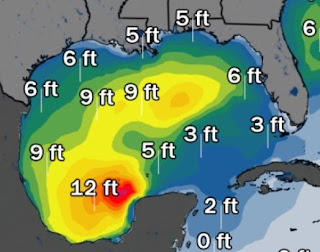
Despite being hundreds of miles south of Louisiana, offshore wave heights are 5-6'. Boaters should stay in protected waters until Milton reaches Florida late Wednesday evening.
Unlike yesterday, today's models are in much better agreement with the bullseye being Tampa Bay. This will be a large storm so impacts will be felt hundreds of miles from the centerline track. NHC has INCREASED the storm surge around Tampa Bay to a record 10-15'+ !!! There will be water where folks never saw water before.
Since Milton should be a fast mover, rainfall amounts will remain modest in the 4-8" range and will NOT head into the Carolinas like Helene.
With a general upper trough over the eastern states, the circulation around Hurricane Milton will draw down the much drier air to our north. That will provide us with near perfect mid-October weather.
So while our friends in Florida are about to begin more suffering, much of the country is enjoying great weather. It is getting cold up north and that has the trees turning colors as my friend Steve Miller shows us from upstate NY.
Or how about being in Albuquerque for their annual balloon festival?
The referee signals when the balloons can launch and they number in the hundreds. Thanks to my oldest (Rob) for getting me those pics. Prayers for Florida Gang. Let's hope those who should evacuate, do so. FYI, Cantore is in Tampa. Yikes! The only thing that could save Tampa from the big surge is a jog to the south in the centerline track. Of course that brings worse impacts to Sarasota southward to Ft. Myers. Stay tuned!


No comments:
Post a Comment