Yesterday I showed you some graphics as to why the computer models, which were forecasting 20% rain coverage for today, would be wrong. We have very dry air in the mid to upper levels and only in the lower levels did we have any moisture/humidity. Without any front around and with the lower sun angles, I felt it would be difficult to develop any showers. But wrong Weather Breath! Radar doesn't lie.
I guess that is about 20% coverage? But what has changed? The upper levels are still dry.
So what caused the surface convergence that formed these showers? All I can think of is the tremendous increase in winds around a strong surface high bringing in higher dew points with the moisture piling up along the Louisiana coast.
Look how wave heights have jumped compared to yesterday's 2-3 feet. Our dew points are back around 70 making it feel muggy again.
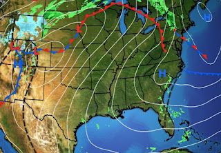
80 degree warmth has spread all the way up to Chicago & Green Bay. But look behind the front over the Rockies where snow is falling.
The 7 day rain totals keep the heaviest amounts well to our west, but as computer models are showing, there will be some spotty showers over SE LA. The FOX 8 forecast has increased rain chances on Thursday (Halloween) to 60%.
I believe that may be a bit too aggressive since most of us are in day 25 without rain. But give the models some respect! One thing for sure is no cold air is coming for at least another week. Finally,
If we see another named storm in November it will be in the Caribbean. Several models keep hinting something might try to develop next week. Strong WSW upper winds will keep anything from getting into the Gulf. Stay tuned!


.jpg)


No comments:
Post a Comment