The NWS forecast from yesterday proved to pretty much be on target with widespread rain totals of 1-2" and locally some heavier amounts (3-4"+ North Shore, along coast) that caused brief street flooding. The "worst case scenario" (6-8") didn't happen since the line of storms continued to move quickly to the east. The heavy rains are now east of Mobile Bay over the Florida beaches. This was NOT a cold front, but more an upper trough moving through. Even the drier air at the surface lags back to our west as the dew points drop into the 40s.
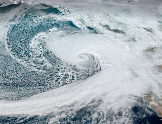
As the upper flow becomes more from the NW, the cooler air will filter over us, especially Wednesday PM into this weekend. The current upper flow hasn't shifted yet, but it will. The top satellite view is the current flow. Note the huge low west of Seattle.
That storm looks like a hurricane, acts like a hurricane (Buoy winds to 69 MPH) but is a "cold core" winter storm. It will linger off the West coast for days but a piece of energy crosses the Rockies tomorrow deepening the Great Lakes upper low. Here's the timeline. We begin with an upper low over the Dakotas.
The second graphic is valid for Wednesday PM followed by the bottom valid for Friday AM. That sharp little dip will bring down the chilly air. However, look at the upper pattern for Sunday.
We go back to mainly a west to east flow across the southern states. Why is that important? Because it is getting REALLY cold up in Canada & Alaska.
Burrr! 35-40 degrees below zero and it's still November?!!! My experience tells me if Alaska gets unusually cold, look for that frigid air to plunge southward in 10-14 days. I've mentioned in previous posts, after a very long warm stretch, the weather often will go to very cold. Snow lovers, don't give up on some snow next month!
Tomorrow will probably get back into the 70s before temps start to fall in the afternoon.
Obviously, the FOX 8 weather page is having a problem. You get the idea about the coming chill. You'll need sweaters & jackets. Stay tuned!


No comments:
Post a Comment