It took until after 1 PM for the low clouds to break, but we should now enjoy 3-4 bright days with full sunshine. However, a secondary surge of cold air will arrive during the afternoon on Friday requiring folks north of Lake Pontchartrain to take precautions for pets & plants. This coming chill should be no worse than the previous one. I am bringing my more tender tropical plants into my He-Shed for tomorrow night. Here's what the local NWS office is forecasting.
Despite skies clearing, the real chill remains far to our north for tonight.
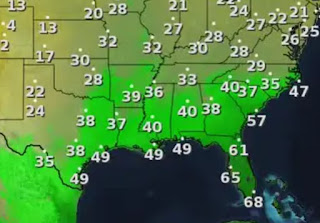
Dewpoints (bottom graphic) have fallen into the 40s, but the secondary blast of cold air is still north of Omaha. It will surge to the southeast during the day on Friday. The top graphic is valid for Friday at 1 PM. You'll notice an increase in northerly winds that will require the heavy coats for Saturday & Sunday.
The core of this Arctic blast should remain to our north & east as the upper flow across the South is west to east. The current "clipper" is roaring across Wisconsin with a smaller clipper flying into Iowa. A band of snow is dropping 2-4" with gusty winds and near whiteout conditions.
As usual, the mainstream media is overhyping this system and all it's doing is bringing SEASONAL cold to where it's supposed to be cold. Note the temperature in Sioux Falls, SD is 17 while Omaha is 45. For us, this cool-down will be fairly brief with a warm-up coming by PM on Sunday.
As I mentioned above, I am bringing in my tropical plants this weekend, but I don't think I need to cover my inground flowers. We'll check on that again tomorrow. For now enjoy the 3-4 days of sunshine before the next warm-up brings us some rain for Christmas Eve & Day. Car travel across the South should have no issues this weekend. Stay tuned!


.jpg)

No comments:
Post a Comment