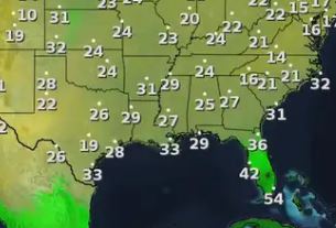
We have reached, historically/climatologically, the 3 coldest weeks of the year where our normal/average high is supposed to be in the lower 60s. That will happen later next week, but tonight I've got my plants protected again as skies are clear and winds are light. That should make for a light freeze away from Lake P. and widespread frost everywhere IF skies stay clear. Satellite views show just that along with the nearby snow cover to our north.
What will change on Sunday is a return of the clouds as a weak gulf system passes to our south.
Dew points are quite low and temps will crash once the sun sets. The rain threat won't arrive until after dark tomorrow and should be gone early on Monday.
Most of the white on satellite views to our north is snow on the ground. You can tell when you zoom in and see the rivers pop out. Everything below the yellow line is snow on the ground.
I know many of you want that snow cover here, but we all know that would shut down all of us for days. In the short term, the center of the surface high will drift over us tonight.
There is some moderation to our west, but I don't see a real warming trend until late next week.
Don't start thinking Winter might be over. Oh no, if you trust the upper air forecast for a week from Tomorrow (Sunday 1-19). The current flow has the upper trough over the Rockies.
By next weekend, that trough shifts over the eastern U.S. bringing a flow straight down from the North Pole. That could bring a hard freeze threat for us with another southern snow storm!. Time to watch it all week. Enjoy the early sun on Sunday. Finally, the fires are still burning over SoCal.
It's just awful to watch the videos showing so many homes not there no more. As we go to church tomorrow, keep our California friends in our prayers as they have many months/years before being back to "normal". Stay tuned!


No comments:
Post a Comment