This will be a quick post since it's Saint's Sunday and we all know where our focus will be!
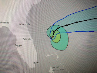
Humberto will probably become a hurricane later this afternoon when the next recon flight is out to measure wind speed. NHC keeps the system well east of Florida with the only impacts along the coast being big swells. The upper low over the Gulf has moved very little since yesterday and is making for a hostile environment for tropical development. NHC has decreased the chances down to 10 % (translation - isn't going to happen).
Clusters of T-Storms remain just off our coast and if there were any northward drift of that low, we could get in on some much needed rainfall. That is not expected to happen with the upper low is predicted to resume a westward drift taking the rains to the Texas coast. Long range models continue to show REAL cold fronts coming after Sept. 25th. That's only 10 days away Who Dat Nation! Go Saints! Stay tuned!


No comments:
Post a Comment