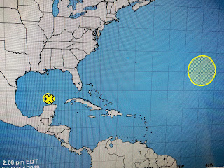
We see during the current Global Warming CYCLE much greater weather extremes whether it's temperature, rainfall or snowfall. We have endured a long record hot stretch over the Gulf South, and my guess is the transition over to Winter-like weather will occur rather quickly, like in the next 10-14 days. Yea we smashed another record today, but relief is coming from the north.
A few T-Storms have developed across the Lake, but they should fizzle once the sun sets. Most of the northern half of the U.S. is now in the 40s, 50s & 60s and, if you can believe computer models, that chill will come in waves. The first real front will arrive late Monday night with a stronger one for late next week with a really strong cold surge around the 20th. Models have a late season storm/hurricane turning up the east coast and the circulation around it will drive the cold air to the south. I'm talking jackets and sweater weather Gang! Even I will welcome a change, if it doesn't get too cold!
The weak low off the Yucatan has too much wind shear for it to develop and NHC now says there might be something form way off the east coat for next week. Since we have fronts coming, I have booked "The Fat Lady" to perform for us (Turn out the lights, the party is over) later next week. We now need to focus on the approaching cold for the second half of October. Stay tuned!


No comments:
Post a Comment