Now that Joe Burrows has won the Heisman trophy, our attention gets back to the Saints & Monday night football. Fortunately we have a covered dome since it appears storms are likely to develop ahead of a cold front that should arrive after midnight on Monday. SPC (Storm Prediction Center) has placed the North Shore in an "Enhanced" level of risk for strong storms with lesser risk south of Lake P.
For today we have no issues as increasing south winds have blown all the early fog away. Those winds over time will open op the Gulf moisture proving the fuel for strong storms on Monday.
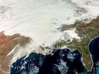
The main storm energy will move out of the Rockies tonight & tomorrow with a band of snow developing from the Plains to the East coast. Already a dense cloud mass covers a large portion of the nation with all of the South in the warm air sector.
The core of the Arctic air will stay to our north and east for Tuesday through Thursday, but parts of the North Shore could dip to below freezing for Wednesday & Thursday mornings. A warm up begins Thursday PM ahead of another system coming in for next weekend. I still don't see an Arctic outbreak coming our way during the next 10-14 days. In fact, Christmas week looks to be mild (60s) and dry. Bummer for Santa. Stay tuned!


No comments:
Post a Comment