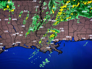
We still could see another line of storms develop ahead of the front, but clearing skies and drier air is heading our way for Monday.
Sunday, April 12, 2020
Strongest Storms staying North of Lake P.
We are still in the warm air sector so even though the severe threat is diminishing, it will not be zero until the cold front passes around midnight. RIGHT NOW, the heaviest storms will miss the South Shore while the North Shore is getting a good soaking.
We still could see another line of storms develop ahead of the front, but clearing skies and drier air is heading our way for Monday.
Again, as the upper energy pulls farther away, our risk for severe weather continues to decrease south of Lake P. . If you live north of Lake P., a Tornado Watch has been extended until midnight. Keep your phone handy just in case something unexpected blows up during the next couple of hours. Hopefully we'll just get a few brief downpours with the high winds and hail remaining much farther to our north. Nicondra Norwood will have the latest info on FOX 8 at 9 PM. Stay tuned!
We still could see another line of storms develop ahead of the front, but clearing skies and drier air is heading our way for Monday.
Subscribe to:
Post Comments (Atom)


No comments:
Post a Comment