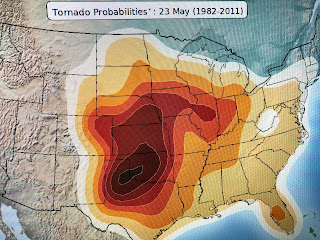
As we approach the beginning of the 2020 Hurricane season, we leave behind our typical tornado/severe weather "season". We really don't have a season for severe storms like other parts of the country, but it's of some comfort to know that the long term climate averages for risks of severe storms has now shifted to the central Plains.
That's exactly where SPC has the greatest threat for this afternoon. As we get into late May & June, fronts usually stall out before reaching us. The trigger for producing storms now is either daytime heating, the land/sea breeze front or an upper air disturbance.
The close in satellite views show the pop up nature of the showers/storms and lightning then becomes an almost daily issue. We have no fronts around nor do we expect any. Next week beginning late Monday looks to be wetter as an upper air "cut off low" develops over Texas. We'll have to watch out for a heavy rain event as we'll be on the "wet side" of the Low.
All of the South has warmed up along with most of New England. Under the cloud cover & showers, it's not so warm. The real chill is over the western states where an upper trough is creating sweater & jacket weather.
Finally, I'll be in my backyard playing with my girl friend Bailey. In my next life, I want to come back as a dog where all you do is lay around and sleep, play occasionally, and wait for your parents to feed you and take you for walks. As you can see, Bailey is thinking..."What a Country!" Enjoy your weekend & stay tuned!


2 comments:
Thank you, again, bob Breck. Still missing you on air. Enjoy and stay safe
Thank you again,Bob Breck. We still miss you and your reports. Stay safe and enjoy.
I always look forward to your references to Colorado, since my daughter and family moved there five years ago. I've often heard and read your references to your son in Longmont Co.
Post a Comment