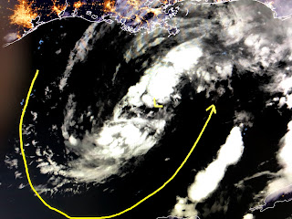
If you look at tonight's satellite pictures of Cristobal, it's difficult to determine where he is and/or what he is.
You can see where dry air has been entrained all around the system making it elongated from SW to NE.
The bright colors on the IR loop that were off Florida's west coast have moved inland and weakened with very few bright clouds around the center of Cristobal. He is running out of time to get better organized as he's less than 24 hours to landfall.
Recon reports indicate the storm hasn't strengthened and NHC hasn't changed the track at all. Radar shows a large rain shield across all the the northern Gulf, not like a typical tropical system that has the T-Storms drawn in to the center of circulation. Heavy rains here appear to be our greatest threat for tomorrow into Monday.
I really have nothing to add except get a good night's sleep and we'll give it another look tomorrow morning. Sorry for being late but I'm having computer issues. Stay tuned!


4 comments:
Thanks, BoB@
Thank you, Bob, for keeping us all informed.
thank u Bob
Voice of reason in a sea of hysteria,
Thank you
Post a Comment