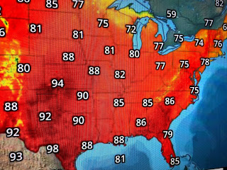
These are the pictures I was trying to use with this afternoon's post. It's rare for a summer day not to have any storms around during daytime heating. You have to look back to Florida to find any rain.
You can see how far down into the Gulf yesterday's front has pushed and models are indicating it will stay there for most of this week as a secondary push of dry air arrives on Sunday. The center of the high is to our north and east and you can see the drier air in the much lower dew points.
Our dew points dropped from the 70s into the 60s and highs stopped short of 90. That's still hot, but with lower humidity, it didn't feel as bad. Hope you can get out and enjoy this summer treat because you know it can't last.
The area nearing Barbados that NHC was watching yesterday has turned into just an open wave. More importantly, look at the amount of African dust pouring out into the Atlantic. David showed a model earlier this evening showing that dust moving westward into the Caribbean for next week. That should keep that part of the tropics quiet. No model is hinting on any development for the next 7-10 days. Stay tuned & sorry for the computer issues.


No comments:
Post a Comment