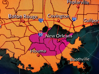
The 3 pm temperature of 99 sets a new record and we still have time to hit triple digits. Of course it's the high dew points combined with the temps that make it unbearable to be outside.
Some storms are starting to fire off and coverage this afternoon will be greater than yesterday. Here's what's causing our excessive heat.
There is a stalled upper high over the Rio Grande that will slowly lift to the north and expand east to west across the country. As that happens, our current NW upper flow will shift around to the east allowing tropical moisture in the upper levels to increase later this week. Before then, we currently have the axis of the Bermuda high suppressed far south over the southern Gulf with westerly (hotter) winds across the northern Gulf including us.
In addition, there are no tropical waves coming across the Caribbean so it may take until next week before we see our usual widespread daily storms making us less hot.
I'm always looking for neat things to show you on satellite pictures. The top two pics are from yesterday just before sunset when the low sun angle created a large shadow effect pointed out by the arrow. Today pics is over Lake Michigan showing how the lake breeze front has pushed inland all around the Lake and how the north winds have pushed all the clouds away from the south end of the lake making my hometown (Hammond/Whiting/East Chicago) beaming with bright sunshine. With temps. 75-80 and low humidity, it doesn't get much better. Just don't go there in Dec-March! Stay tuned!


1 comment:
But Bob, that MSY reading is probably 3 to 4 degrees too high because of poor siting. If that isn't corrected, many more records will fall incorrectly.
Post a Comment