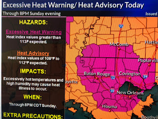
I mentioned in a post last week that we were going to see a "heat wave" for this week as an upper high builds eastward. No big deal, happens several times during the hottest months and in the past it was called SUMMER. But I came across this graphic posted by Jeff Berardelli of CBS News.
Jeff wrote, " relentless heat wave to bake the U.S. for 'multiple weeks' ". I had to look up what "historic" meant, and by definition means "famous or important/momentous". Geez, is every summer heat wave going to be called "historic"? Tell Dallas residents during their hottest summer (believe it was 1980?) when they had 42 straight days above 100 that it wasn't historic. Seems every weather event ( err, I mean extreme) has to be hyped like it never happened before. Did the hottest summer ever (1936) not exist? Sure it's hot, but let's remember what time of year it is.
Since this morning's low was 83, we're very likely to flirt with 100 this afternoon and our local NWS office has correctly issued an "excessive heat warning" for us today. The only thing that might stop us reaching triple digits is some clouds and a late PM T=Storm.
Satellite pics clearly show the lake effect with no clouds over Lake P. with clouds building along the lake breeze front. Let's hope we see a couple of PM cooling storms.
Otherwise no major changes until later this week when the upper high shifts to the east allowing an easterly flow over us. That would increase of rain chances a little. At 11 AM, the 93 degree surface temp. coupled with the 78 degree dew points gives us a heat index of 110! At 11 AM !!! Stay cool and stay tuned!


1 comment:
What about Saturday the 18th of July?
Post a Comment