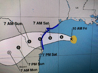
Her center of circulation is just now coming into land based radar views so she'll be easier to track as she heads towards the Texas Coast. Hanna is moving WNW and the NHC track takes the centerline path south of Corpus Christi meaning they will be on the stronger side of Hanna.
We continue to see some rain squall rotate around Hanna over us and computer models keep predicting 1-3+" of rain here during the next 24 hours.
The main impacts locally are higher tides and a Coastal Flood Advisory, but our winds haven't been very strong. The cloud cover and spotty showers are keeping temps in the 70s & 80s so we're getting a break from the brutal summer heat. Gonzalo remains far out there and I'll talk about him later this afternoon. For now, enjoy knowing Hanna isn't our problem. Stay tuned!


No comments:
Post a Comment