Way out in the Atlantic is a small swirl that has not become better organized today. IF it came straight to us (very unlikely), it wouldn't arrive until the end of NEXT week.
The second system that was over Haiti yesterday is over eastern Cuba today heading on a path towards the Texas coast late this week.
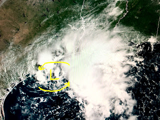
Satellite loops indicate it too hasn't showed any signs of organization, but NHC believes conditions may become more favorable as it moves over the central and western Gulf. My favorite disturbance for the name Gonzalo is just off shore south of Galveston. It has very little time to develop, but cloud and radar views do show some banding with a low level weak circulation.
NHC has a recent history of naming systems that near coastlines so I won't be shocked to see Gonzalo later today or tonight. You can see the bigger rain shield is far to the right (east) of the circulation. That cloud and rain shield has had an impact on our local temps.
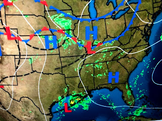
Otherwise, the surface weather map has the Atlantic Ridge to our north bringing us a typical SE flow in off the Gulf.
Some cooler air has moved down over the northern plains and Great Lakes, but a good part of the country is dealing with the kind of heat & humidity we get every day. Boston & NYC are 90+ with dew points 70+. They'll get relief with a cold front later this week, but we have to wait until late September or early October for our first real front. For now, our attention will be on the Tropics to see if any of these waves develop and become our next named storm. Stay tuned!


No comments:
Post a Comment