Picking up on my post from yesterday, Joe Bastardi of WeatherBell Analytics talked about this being the quietest July since 1998 regarding Tropical activity worldwide.
Before you go cancel your home owners insurance, remember it is only July and we have over 90% of the season to go. The Gulf and Caribbean have few clouds and nothing to follow, but the "African Wave Train" appears about to leave the station way out over the eastern Atlantic. There we have a cluster of clouds heading to the west which will take 2 weeks to get to us IF it were to develop. Computer models are not showing that to happen.
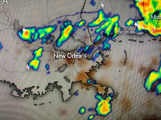
Locally, we are seeing more clouds and showers bubble up as a weak upper low is just NE of Mobile. Kenner picked up a quick 58" with the result being a drop of 12 degrees in less than an hour.
We'll take any relief from our brutal heat and tomorrow should see a repeat as the upper low drifts slowly to the west along the northern Gulf coast. The "historic Heat Wave" that was supposed to last for several weeks has taken a short break, but it'll be back. Looking ahead, 8 weeks from now puts us into mid September and that should mean looking for our first cool front. Nah, let's not look too far ahead!
Finally, you know how much I love picking out features on satellite pictures. These are from yesterday with the arrows pointing out the shadows cast by the tall storms here, and by storms over Florida. When the weather gets boring, the daily heat story gets stale, look to picking out small features on satellite loops to keep things interesting. Stay tuned!


No comments:
Post a Comment