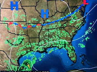
Sure the clouds and showers keeps us cooler, but enough is enough! A long band of T-Storms has set up from Mobile bay through metro NOLA westward to south of Lafayette bringing wave after wave of heavy downpours. My house now has received over 4+" over the past 3 days and it's still pouring. MSY is now the 4th wettest July on record and only needs less than 2" to become # 1.
The surface map has no clue why we keep raining as we have no fronts around. However, I can point out 3 upper level lows on the satellite view. One is over south Texas triggering the storms over the western Gulf. Another is to our northwest over Kansas & Oklohoma. Those are not the problem.
It's the weak upper low over southern Mississippi that is triggering our storms. That low will slowly lift to our north tomorrow and that should result in a drying trend for Thursday through Saturday.
Now to the Tropics.
The broad circulation in the Atlantic is approaching the Islands and NHC now call it "Potential Tropical Cyclone #9". A recon aircraft could find no real center this afternoon so they haven't made it a depression or named Storm (Isaias) yet...but they will.
They are issuing forecast tracks and, based on many models, they are curving it towards south Florida. Our pay attention day will be late Friday into Saturday when we should know if it'll make the turn and not head into the Gulf, or if it heads farther to the west and gets into the Gulf. Models so far are NOT bullish on making this a strong storm. Plenty of time to watch. Focus on our flooding rains for now. Best stay home next few hours since flooded cars are no fun. Stay tuned!


No comments:
Post a Comment