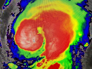
I told you I would be back around 10 pm, but after reading the comments of many fearing Laura has turned to the north, let me go over the latest NHC position. At 4 PM they said Laura's forward motion was WNW @ 17 mph. At 7 pm that motion remains WNW (300 degrees on the compass) @ 17 mph. There has been no change in direction. To confirm...at 4 pm she was at 24.7 N latitude and at 7 she moved to 25.0 or .3 of a degree north. At 4 pm she was at 88.3 West longitude and at 7 she moved to 89.0 or .7 of a degree west. She clearly is NOT moving more to the north.
What has changed is the structure of the storm. The top pic is from 3 pm with the main cluster of storms on her south and east sides. Now at 7 pm we have clusters of storms all around the center (arrow). Recon has pressures dropping so NHC increased the max. winds to 85 mph. This is a developing strong Hurricane that is predicted to become a Cat. 3 or higher. Watch to see if we start seeing that doughnut hole feature by morning.
I seriously doubt they will make any radical changes to their track forecast come 10 pm. Several words of caution...Going to various blogs that have individuals with limited or no weather credentials can be dangerous. Back after 10 pm. Stay tuned!


14 comments:
sure likes like a big one diameter -wise.
4:00 PM UPDATE - Laura is not moving West-North-Westward like previously anticipated. This means a more eastward Landfall is possible more to the the east then where the forecasted Cone-Of-Uncertainty states it will be. If you live near New Orleans, LA, you are not completely out of the picture yet. If this high pressure to the west of the remnants of Marco fails to build, a North Westward progression will become more and more likely than a West-North-Westward Progression. Stay tuned.
So what about this from mobile weather center??
That’s what I saw too and it had me concerned. Like who do you listen to?!?!
For those of you wondering about the trig of a storm moving 0.3 degrees North and 0.7 West, that comes to movement at 293 degrees, which is just under the 300 degree mark of WNW. Bob, and the NHC, are correct.
Trust in Bob
Thank you Bob! I enjoy reading your blogs and have complete confidence in your input. I look forward to 10pm and thanks again for sharing your weather knowledge with us.
Bob knows more than the weather people of today I trust bob
My daughter is in a ground floor apt in Baton Rouge. Should I have her evacuate?
Wendi Sancho Maddox
Thank you Bob for doing this!!!!
Thanks Bob for giving us something to hang our hat on. I trust the information that you provide!
Thanks Bob. The only sources I'll ever rely on are the NHC/NOAA and you.
I live near the Lake front(gentily) should i be worried
Bob has been doing for 50 years yet some of the people on this blog, with no experience, think they no better
.crazy.....Bob is the new Nash..
Bob has been doing for 50 years yet some of the people on this blog, with no experience, think they no better
.crazy.....Bob is the new Nash..
Post a Comment