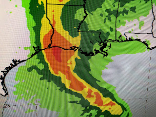
After seeing the overnight models shift the center line track farther to the west, I felt it would be difficult for Laura to make any radical move to the north and threaten us. The newest NHC forecast track is almost identical to the one this morning.
The top graphic was issued at 4 AM with the bottom 2 from 4 PM. Can you see any difference? Even the timing of land fall is the same telling me the Hurricane forecasters are getting more confident in the accuracy of all the models. Laura is almost to 90 degrees west longitude meaning SE LA/MS should only get a glancing blow from this storm.
The rainfall forecast is for 1-2" over SE LA. with heavier amounts the farther one goes westward. Wind-wise, there could be some gusts to 40-50 mph tomorrow from Houma/Pt. Fourchon westward.
Clearly, the bullseye for strongest winds focuses on along the TX/LA. state line As Laura strengthens and passes to our west over night into Thursday, look for a tidal surge of 3-5' into Lake Pontchartrain that will push water over the sea wall on the North Shore. The surge along the coast west of the mouth of the River will be 4-6'+ , especially around Cocodrie/Dulac. We probably will see tornado watches issued during the next 2 days that might include us.
I showed you this satellite view of Hurricane Dorian last August with the classic looking doughnut shape, So far Laura doesn't look like that, but she's trying.
It's pretty obvious an eye is trying to appear and I fully expect Laura to resemble Dorian's appearance as she gets into the NW Gulf. Her forward motion remains fast (WNW @ 17 mph) and that is very good for us. Expect her to slow down soon and that will allow her to make the turn around the high to the north.
After Laura leaves, the tropics look to be quiet for several days and that should get us into September. Until I start to see those cold fronts coming, I haven't placed a call into "the Fat Lady". Since Covid, she really hasn't had a gig so she's ready to burst into our song..."The party's over". The bottom picture shows what's left of Marco, a tiny swirl south of Lake Charles in case any of you were interested. Right now, all is looking good for SE LA/MS, but we need to start the prayer lines going for areas to our west. Next update after 10 PM.


10 comments:
Do you think it could reach Cat 4? I have family in DeRidder that doesn’t want to leave. 😩😩
What are the surge warnings looking like for Lafitte,LA? Are we in that 4-6’ range?
How do you think we look in the Bedico area, as far as surge into the swamp?
Question there is a radar map that shows lauras eye outside the cone...Could this mean she has shifted back east some but for whatever reason its been missed??
Bob you always said to watch the pressure. If the pressure is going down it is not good. If the pressure is going up we are doing great. According to the weather from Mobile all the way to Houston. The pressure is going down. My gut said it will be closer to lake Charles and new Iberia.
Nola will get some bad weather if that happens what do you think?
Here in lafitte we are comparing it to Rita which left us with major flooding. What are your thoughts on this Bob?
Does anyone in here realize that Bob is NOT going to answer your questions. Just read the damn blog for the detailed information he’s providing and watch the news for all the questions they’ve already answered every hour since Sunday.
DeRidder is too far inland north of the coast to be that badly effected. Hurricanes weaken as soon as the hit the coast line.
For some reason, your most recent update did not reach me via blogger.com. Could not open your blogs yesterday. Got nebulous servers being upgraded error. I can find you on net no problem. Something wrong with subscription service.
Not so. My parents house got water in it for Rita. The first and only time that’s ever happened. DeRidder got 109 mph winds that time. It was hard to get them to leave then and it’s even harder now. According to the 8/26 4 am track, the eye is going to pass 20 miles to the west of their house.
Post a Comment