When I left you last night, I talked about a track trend that could be shifting farther to the west *away from us), Indeed that continues as NHC now has their center line west of Lake Charles up the Sabine River. Here's last night's track.
It was right over Lake Charles making landfall as a Cat. 2 Hurricane Thursday morning. Here's the newest track that has it 30 miles to the west up the TX/LA border.
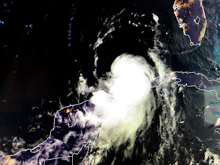
In addition, the computer model runs all favor an even further west trend increasing the danger for Galveston & Houston. Note also the M at landfall. That indicates it will be a Cat 3 or stronger storm. So let's check our her appearance on satellite views.
Compared to last night, Laura's structure has improved greatly with only the western side lacking storms. Without any wind shear, she should easily wrap storms around her center and I expect an eye to pop out later this afternoon. NHC has just upgraded her to a Hurricane.
IF the NHC track proves true, this westward shift lessens any impacts on SE LA/MS. We'll see some gusty winds at times, especially tomorrow along with higher tides. Also, since we're on the "wet side", there could be a slight threat for tornadoes this afternoon and tomorrow. Another negative...her forward motion has slowed from 20 mph down to 17. A slower motion allows bigger storms an opportunity to make the turn . I just don't see that happening. In fact, watching Shelby on FOX 8, she just showed the VIPIR model that takes Laura into Houston. If your have friends or relatives there, call them and tell them..."Houston, we have a problem". Finally, remember my experience with models. Computer models have difficulty with smaller, weaker storms. They do much better the bigger the storm gets. Since I'm less nervous, I may go play golf this morning. Next update won't be until later this afternoon. Stay tuned!


18 comments:
Birds started fussing for their feeder, they are happy now and hanging pots are enjoying the rain.
YUP! I took my afternoon bike ride,and the birds are definitely back!I was ecstatic to see them.
The last 3 positions are more north against the model predictions. Is an eastward shift still poasible
The satellite picks resembles an embryo. She will develop into an adult real fast. Houston we have a problem
I thought it was Elvis taking a sip of coffee.
Bobs a reall class act.. not. Four!
Thanks Bob.....enjoy your golf game....
Thanks Bob, waiting for your next update, enjoy your day.
I see 4 tenths to the north and 4 to the west. That's NW to me but I guess time will tell.
Should I need to worry about flooding on Barataria side with the weather
How much tidal surge do you anticipate on the Northshore of Lake Ponchartrain at (CarrDr.) Slidell.
Anyone else see a more Northwest movement than WNW, like predicted? I know I'm no meteorologist, but one channel had the projected path on screen with the satellite image, and it sure looked like a more NW drift to me
Looks like I will be keeping my doctor appointment tomorrow morning..thanks for all of your posts!!
Looking at all satellite images in my opinion I seen a slight wobble to the north
I'm thinking more of an Eastern impact around Pecan Island im no meteorologist but living out here all my life in Louisiana and tracking them that what my I think in my opinion
How will the remnants of Marco affect Laura's path?
Bob, would you post some photos of your he-shed?
Post a Comment