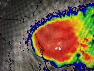
Tonight's satellite & radar views tell me Tropical Storm Isaias is about to become a Hurricane once again. There continues to be a burst of convection/T-Storms well off Florida's east coast and it looks to me like a new center is trying to form farther to the east.
In fact, it appears an eyewall is trying to wrap around the western side where no storms were for most of today. Fortunately for Florida, Isaias will stay far enough to your east so any impacts will be confined to coastal locations. Since he's over the Gulf stream, don't be surprised to see NHC increase Isaias back to a hurricane either on the 10 PM or 4 AM updates.
NHC's track forecasts have been pretty good and if I'm in the Carolinas from Charleston northward to the Outer Banks of N.C. get ready for impacts far greater than what side-swiped Florida. After that, heading up to the big cities of the NE, Isaias will be a prolific rainmaker dumping 4-8" that certainly will cause some local flooding.
Farther out in the Atlantic, NHC indicates a swirl NE of Puerto Rico has a good chance (60%) of being our next named storms (Josephine). Fortunately it'll not be an issue for the U.S.
Locally, my thinking hasn't changed. As Isaias moves up the east coast and an upper trough moves across us, we should see a weak cool front push through on Monday drying us out for most of this week. Look at the dew points in the 50s & 60s to our NW. Dallas is down to a DP of 59! Daytime highs will still top 90 this week, but the lower humidity should allow the night lows to feel great, especially north of Lake P. We're still 6-8 weeks away from getting some really cooler temps in late September, but for August, just lower humidity is a start! Stay tuned and tell your friends in eastern Carolinas to get ready for heavy rains, strong winds (gusting to 70+) and power outages.


No comments:
Post a Comment