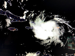
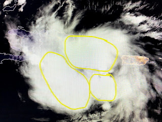
Looking at the satellite loops tonight reveal 2 storms that are struggling, but for very different reasons. Marco is encountering SW upper wind shear over the Gulf that should keep it from becoming a Major Hurricane. Laura is encountering the mountains of the Dominican Republic & Haiti that should keep her from strengthening in the short term.
We begin with Tropical Storm Marco that has broken into 2 areas of storms. As the storm moves farther to the north into the stronger wind shear, I think it will have a difficult time reaching hurricane strength for any length of time. NHC's intensity forecast does make it a 80 MPH hurricane as it approaches our coast.
Their new center line shifted slightly to the left (west) moving right over Grand Isle. I would like this westward trend to continue on Sunday. Regardless, we will be on the "wet side" of Marco and heavy rainfall will be the major threat except along the coast where storm surge and winds create the need to evacuate if you're outside the levee protection.
Tropical Storm Laura looks stronger than Marco, but she too is seeing her inner core disrupted by land interaction and not wind shear. In fact, I'm still way more concerned about Laura since the wind shear currently over the Gulf will be gone when she arrives.
NHC has not changed the center line track at all still moving it right over Houma. Our best hope would be for Laura to either track farther to the south and west (25% chance) giving us a glancing blow, or making the turn to the north sooner keeping the center/eyewall far enough to our east (25% chance) keeping us on the weaker side of the storm. Note how wide the cone of error is at landfall. If Laura made landfall around Lake Charles or perhaps at Mobile, NOLA would be spared any major damages. I will not close my hurricane shutters for Marco, but will wait to see about Laura. Without shear and her being over the warm Gulf waters, there is the potential Laura could become a Cat. 2 or 3 hurricane. I'll spend Sunday getting my yard ready for Marco. It's Laura that makes me nervous RIGHT NOW if the NHC forecast track proves correct. Still plenty of time for that to change. I suggest you watch David Bernard on FOX 8. His graphics are superb, his explanations outstanding and, most importantly, his demeanor calming. His knowledge plus experience should earn your trust. I'll be back tomorrow morning. Stay tuned!


3 comments:
Less than 24 hours ago you said Marco would have a hard time becoming a hurricane now your doing that flip flop to save face and changing it to say hard time becoming a major hurricane..
Shut up that man helping us his was one of the best weather reporter he don’t have to say shit to us
Stfu
Post a Comment