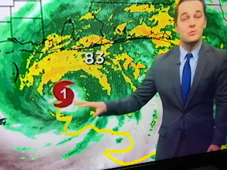
That's confirmed on satellite and radar views as Hurricane Sally appears to be getting better organized and stronger. Let's look at the radar views that show the definite pull to the east.
For the first time an eye is showing and it's already due south of where the NHC's previous track had landfall (Gulf Shores). That is confirmed on the bottom photo showing the eye some 20 miles east of the previous track. I won't be surprised to see the new track shift landfall farther to the east with the center line over Pensacola or even farther to the east. In addition, Sally could/might increase back up to Cat. 2 before landfall? Recon is finding a rapid drop in pressure so they have got to increase her winds. That might be a stretch since some of her circulation is interacting with land. It's in, here's the new 10 pm info from NHC (National Hurricane Center).
They have nudged their future center line track slightly to the east with the center line now over Pensacola. That required them to shift the Hurricane warnings farther east too. It now goes to the Okaloosa/Walton County line that includes Ft. Walton & Destin. Winds are 85 mph, but David just showed some off shore buoys gusting to 100+. Forward motion is NNW at 2 mph, but what I'm seeing is faster movement on radar. It's still going to take another 7-8 hours before Sally's center reaches the coast. This new eastward shift means places to the west of the center line like Dauphin Island, Mobile Bay & Pt. Clear will miss the greatest storm surges.
The surface set up still has the large high drifting off the East Coast allowing Sally to finally make the move to the coast. An upper trough moving out of the Rockies will help accelerate that motion tomorrow and Thursday. As our winds veer more to the NW, water levels, especially in Lake Pontchartrain will come down as the winds subside locally. The next 2-3 days look like we'll see sunshine return with no rain.
David & Zack Fradella mentioned the area down in the SW Gulf that could develop later this weekend. I haven't had enough Chardonnay tonight to even talk about that. I loved Zack showing the track of Sally. And you wonder why the model forecasts were so wrong! This has been one of those unpredictable storms, and it still might have some surprises for Florida. I probably won't post until later tomorrow afternoon. Just hope the folks to our east have been paying attention. Stay tuned!


11 comments:
Best in the biz!
If my mom ever comes through with that lasagna I’ll split it with you for sure.
If anyone else wants some lasagna let me know sooner then later. It takes time.
About 25 minutes prep and 45 minutes in the oven. Then take the foil off for another 15 minutes in the oven.
Then of course let it sit for 30 minutes before cutting in.
Anyways.
Bless up!
Y’all let me know.
Peace and love
Love lasagna and I'm not even Italian but i am half Cajun, we Cajuns know good food! Give my portion to Bob for such an awesome job!
Bette
"I haven't had enough Chardonnay tonight to even talk about that." 🤣😂🤣😂🤣😂🤣😂
Thanks for the updates Bob...if whatever else is in the Gulf decides to head north we're all gonna be drinking Chardonnay!
Pensacola? That's amazing Bob! You predicted it again only a few hours before landfall. I predicted a Pensacola landfall on saturday evening
Then maybe you get a job as a TV weatherman!
being a weatherman is the only job i know where you can be correct about 20% of the time and get a raise. lol
Thanks again Bob, for all the guidance during Sally.
Hopefully you're entirely ignoring the "critics" and their tired cynic act. Some weak trolling around here; time to get a new shtick, ya'll.
That’s the Bob I know waits til literally landfall about to occur to make his “forecast”. He would be completely lost without computer models..
Truth hurts ?
All the haters ANONYMOUS and weather wizards in here predicted days ago! You heard me!?!? Hahaha what 's the problem with all these people! Don't come here if you don't need sound storm forecasts!!!
The Official landfall position ended right over Gulf Shores as Sally made a jog to the north right before landfall. Pensacola did get into the eye wall and appears to have received the highest surge numbers.
Post a Comment