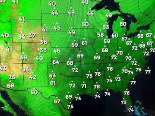
The cold air is growing over northern Canada as the longer nights are taking effect. No real cold is in over the northern plains, but look at how much lower (drier) the dew points are. We will stay dry as water vapor has a huge slug of dry air in the upper levels over all of the Gulf. That shows up on satellite views with few clouds from us over to the Florida beaches.
Now on to the Tropics as Tropical Storm Omar is heading into the open Atlantic soon to be gone while Tropical Storm Nana is closing in on Belize.
The western extension of the Atlantic Ridge has blocked any turn to the north by Nana and she will not be a concern for the Gulf. Way farther out in the Atlantci off of Africa are 2 systems NHC is watching.
Neither of these are likely to concern us as they are 2 weeks away, IF the MJO (Madden-Julian Oscillation) does indeed drift into the unfavorable (sinking air) phase for the next couple of weeks, we may not see much happening during the peak of the season. It's still a long way until October, but I like seeing cold fronts coming down to us in September. Next week could be a real early Fall treat?
Finally, I've been showing you some of my past tracking charts & the folks who made me better. This is the chart from 2005 (Katrina) and featured Chris Franklin, Jeff Baskin & Crystal Wicker. Jeff left me to become the Chief Meteorologist at a TV station in Little Rock while Crystal left to join a TV station in Indianapolis. Local son Chris Franklin stayed with me until I retired. He now is the Chief meteorologist for Ch. 4. I enjoyed working with some very talented people that made Ch. 8 Your Weather Authority. Since all is quiet, I may not update until tomorrow. Stay tuned!


1 comment:
really interesting
Post a Comment