If you think it looks similar to previous predictions, you're correct. The pink along the LA/MS coasts is for a Hurricane Watch as Zeta is expected to maintain at least Cat. one strength at landfall just after dark on Wednesday. There has been a subtle shift to the east in the center line track forecast.
The top graphic from 10 AM had the center line over Golden Meadow and then Slidell. The bottom pic is from 4 PM with the new center line over Port Sulphur & then just west of Gulfport. That is an encouraging trend if it proves reality since it keeps most of us on the weaker side of the storm.
The NHC forecast for arrival time of tropical storm (40+ mph) force winds have them along our coast (Grand Isle) before noon moving up to the CBD by late PM Wednesday. You can clearly see that the strongest winds are aiming towards lower Plaquemines then the MS/AL. coasts.
This will be a fast mover and Zeta won't linger. Rainfall totals indicate as much as 4-6" could drench us. So what would make me nervous?
Currently there is a really cold air mass just to our north & west, much like what happened during Hurricane (Super Storm) Sandy off the Jersey coast. I'm concerned that the interaction of the strong surface high with Zeta could actually increase its wind speeds. Right now Zeta's center is expected to go east of most of SE LA. keeping us with fewer impacts. The farther to our east, the better for us, but the worse for MS/AL/FL coasts.
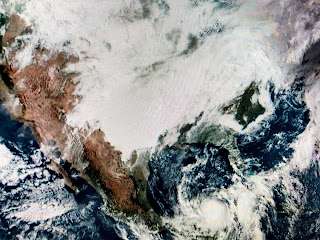
The top satellite view shows the extensive cold air cloud cover not far from us. The next 3 capture a much better organized storm that is nearing Cozumel.
Since much of Zeta is forecasted to pass over land tonight, it should weaken again before moving back into the southern Gulf. Will the Yucatan disrupt the circulation enough to keep Zeta weak as it heads northward? NHC says no. Right now I'm not comfortable talking about local impacts since much of that will depend on the track. I've highlighted the areas east of the center line as most likely to get some significant winds, surge and rainfall. I will determine in the morning what I will take down in my yard. For now I'm doing nothing, but will be prepared to act quickly once we know for certain how close Zeta is coming to us. Next update at 10 PM. Stay tuned!


14 comments:
Thanks so much!!
I'm curious how this might compare to Cristobal.
Thank Bob
Models look to be locking in on NOLA.
THANK YOU!!!!!
There won’t be any definitive info until late Tuesday or early Wednesday.
Storm not coming here as again 5 day cones are worthless and just a ploy to increase grocery receipts. Likely going to hit biloxi/ocean springs. Cone moving just like it has done on every previous storm we were in the cone five days out.
Please stop putting out worthless alerts as all they do is increase people's angst, especially the elderly.
Time to make changes at the NOAA.
NO WORK WEDNESDAY!!
Lost me at "just a ploy to increase grocery receipts," Anonymous, buddy. Interesting conspiracy theory, though, very funny!
thanks for the update.
Yeah I'm sure NOAA gets a percentage of the milk and bread sales. Ignorant people are funny.. sometimes.
10:35 and still no UPDATE.. someone is trying to figure out how to spin their awful forecast?
Nobody gives a damn what you think sir. You're an irrelevant coward!
Hi Bob...so I'm guessing it's not looking good for Southern Mississippi when it comes to Hurricane Zeta?
Post a Comment