As I await the 10 pm update, here's what I'm seeing this evening on satellite loops.
It has taken Zeta all day to recover from crossing the northern tip of the Yucatan, but clearly it is getting a symmetrical look with an apparent eye forming. It is nearing 25 north latitude and will begin to encounter cooler water temps and increasing SW upper wind shear, especially after daybreak. I expect NHC to upgrade Zeta back to a hurricane on their 10 pm advisory.
It's very interesting to watch what is happening over the NW Gulf as colder air is spilling south off the Texas coast. Brownsville is down to 52 degrees! I'm unsure what affect that will have on Zeta as its circulation begins to draw that into it. The 10 PM advisory is in and Zeta is still a Tropical Storm with max winds of 70 mph.
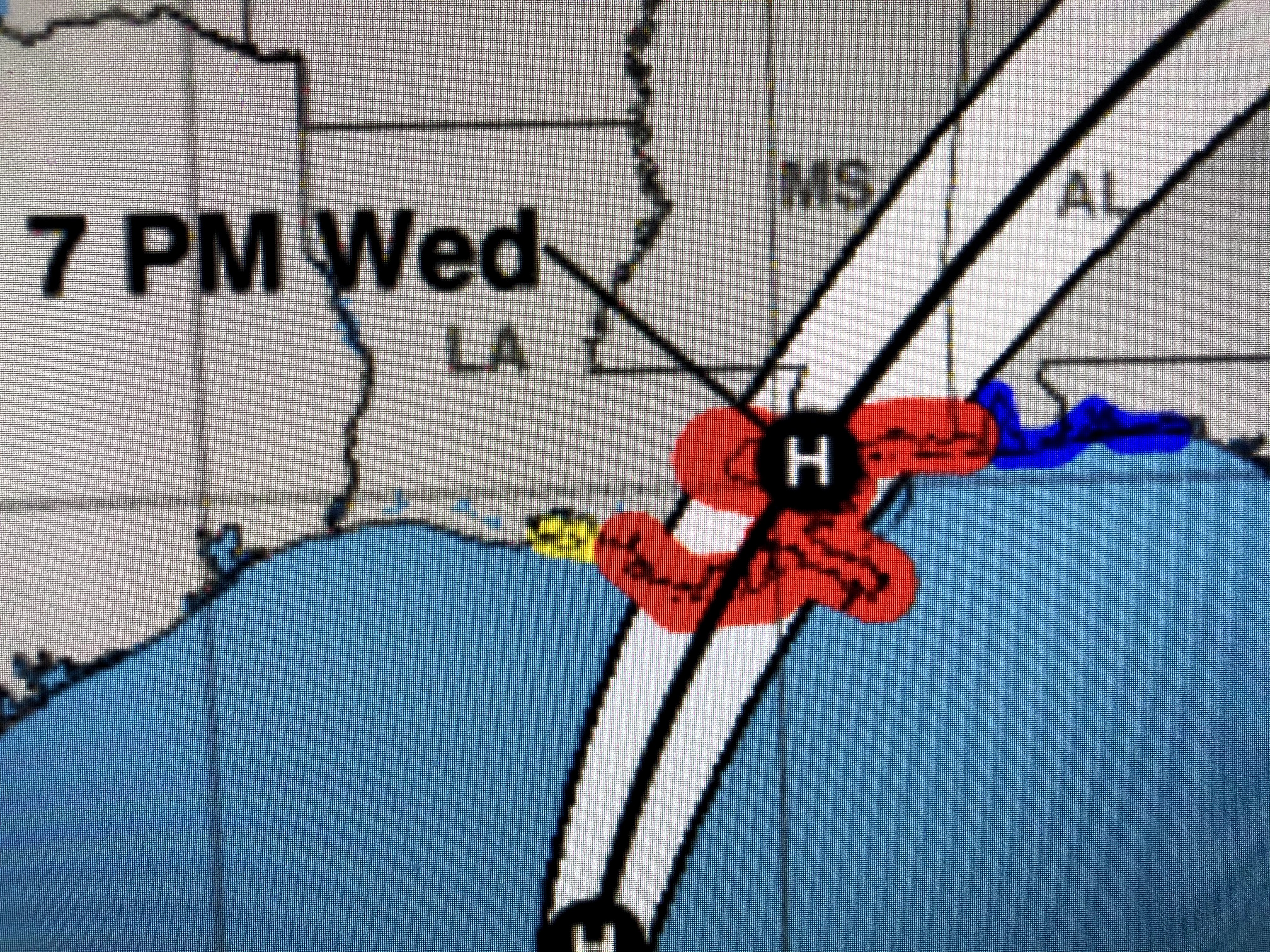
Just looking at the cone you would say that nothing has changed. However, add in the center line future track and you'll see another slight shift to the west meaning the danger to SE LA goes up.
The top graphic is from 4 PM with the center line over Bay St. Louis. The 10 PM update shifts the track back over Slidell, which is where it was on this morning's 4 AM update. IF this shift proves correct, all of SE LA & MS will receive wind gusts to 75 mph. I will move all my potted plants next to my house along with patio furniture. I am not going to close my hurricane shutters unless Zeta rapidly intensifies over night. We'll have time in the morning to climb the ladder. I though David presented several clear graphics showing the timing of the increasing winds on Wednesday with our crunch time coming between 3-9 PM, There is still time for the track to shift back to the east, but NHC's forecast tracks are usually very accurate less than 36 hours out.


Looking at the above graphics, no one should said..."I didn't think it would be this bad". There will be power outages. There will be high waters outside the levee protection/risk reduction system. There could be some brief street flooding. However, Zeta will rapidly accelerate to the NE and be gone before daybreak on Thursday. Power will not be out for weeks, and if we're lucky, only for a few hours for some. I'll update again around 8 AM. Get a good night's sleep and be ready to work your yard in the AM. Stay tuned!


13 comments:
At this point I’ll take anything even if it’s just a tropical storm. I was hoping for the mother of all storms to head our way this hurricane season, but it wasn’t meant to be. I’ll have to wait for next year!
Hurricane lover
the eye (if one officially develops) will pass literally over the center of Lake Pontchatrain on the way toward Mississippi.
Looking at some Cat 1 gust and some spooky debris flying around in the air from Halloween Decorations not taken down.
Beautiful weekend lies ahead with some tacky sweaters making their debut. Good Luck with the storm!
Praying for all in this storms path. 🙏
Hurricane Lover..... We already HAD the "mother of all hurricane's" when we had Katrina!!!!! We do NOT want to see another Katrina here in my (our)lifetime!!!! You are forking with us, right???
Hurricane Lover.. we could be related i too was hoping to see some weather action this season i agree at least we may get a little hurricane drama.
Anybody know about pearl river la Slidell la
Anonymous...you Hurricane lovers! Shame on you! Why don’t y’all take a swim in the Atlantic and you’ll see plenty BIG STORMS!
Thanks Bob. I said the same thing when I saw the 10 PM update That it had shifted a little to West. Glad to here you say this. I will be monitoring your next update. You are you as reliable as you was when you was doing the weather yourself. Thanks for all those many years you gave us and continue to look out for us! Be Safe
Pearl river/slidell area will be hit hard mid to upper 70's with gusts near 90. Robear we usually get a really bad hurricane cat4+ once every 50 or so odd years we are way past due, also hurricane lover I am right there with ya I love storm chasing when I can...with that said thank god we aren't expected to get cat 4 gusts in Slidell I live next to an old rotting acorn tree and a good strong gust might send it into my/neighbors house.
Hi Bob. I'm very concerned with the images on satellite right now. See link below.
GOES16-GM-GEOCOLOR-1000x1000.gif (1000×1000)
https://cdn.star.nesdis.noaa.gov//GOES16/ABI/SECTOR/GM/GEOCOLOR/GOES16-GM-GEOCOLOR-1000x1000.gif
Gonna get wet and windy
I totally agree!!! Keep updating us Bob....we look forward to your updates! Stay safe everyone!
What about Roseland louisiana?? Will it just be wind and rain?? I am very nervous about these storms!! I dont like them at all!!😬😟😟
Post a Comment