A Recon plane has reached Delta and it's finding a stronger system that is almost a hurricane already. The latest track from NHC doesn't look much different with some subtle changes.
Earlier center line track forecasts had it clipping the western tip of Cuba, but now they shifted it to clip the eastern tip of the Yucatan. Because it now goes through the Yucatan Channel and not over land, their intensity forecasts follow computer guidance and they make it a Cat. 3 over the southern Gulf before slowly weakening it as it makes the turn to the north. I still find that hard to believe since the central & northern Gulf are much cooler than 2-3 weeks ago.
The top graphic shows 2 models even take Delta to a Cat. 4 (131 mph+) while the bottom 2 have the oceanic heat content/energy potential with the middle one from Saturday with the bottom one from this morning. I can see Delta becoming a major storm over the extreme southern Gulf, but I just think the cooler waters farther to the north will result in it weakening. This will be a true test of the accuracy of model intensity. They didn't do well with Sally after doing real well with Laura. Now back to that track trend.


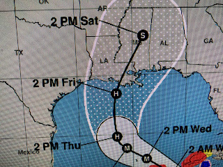
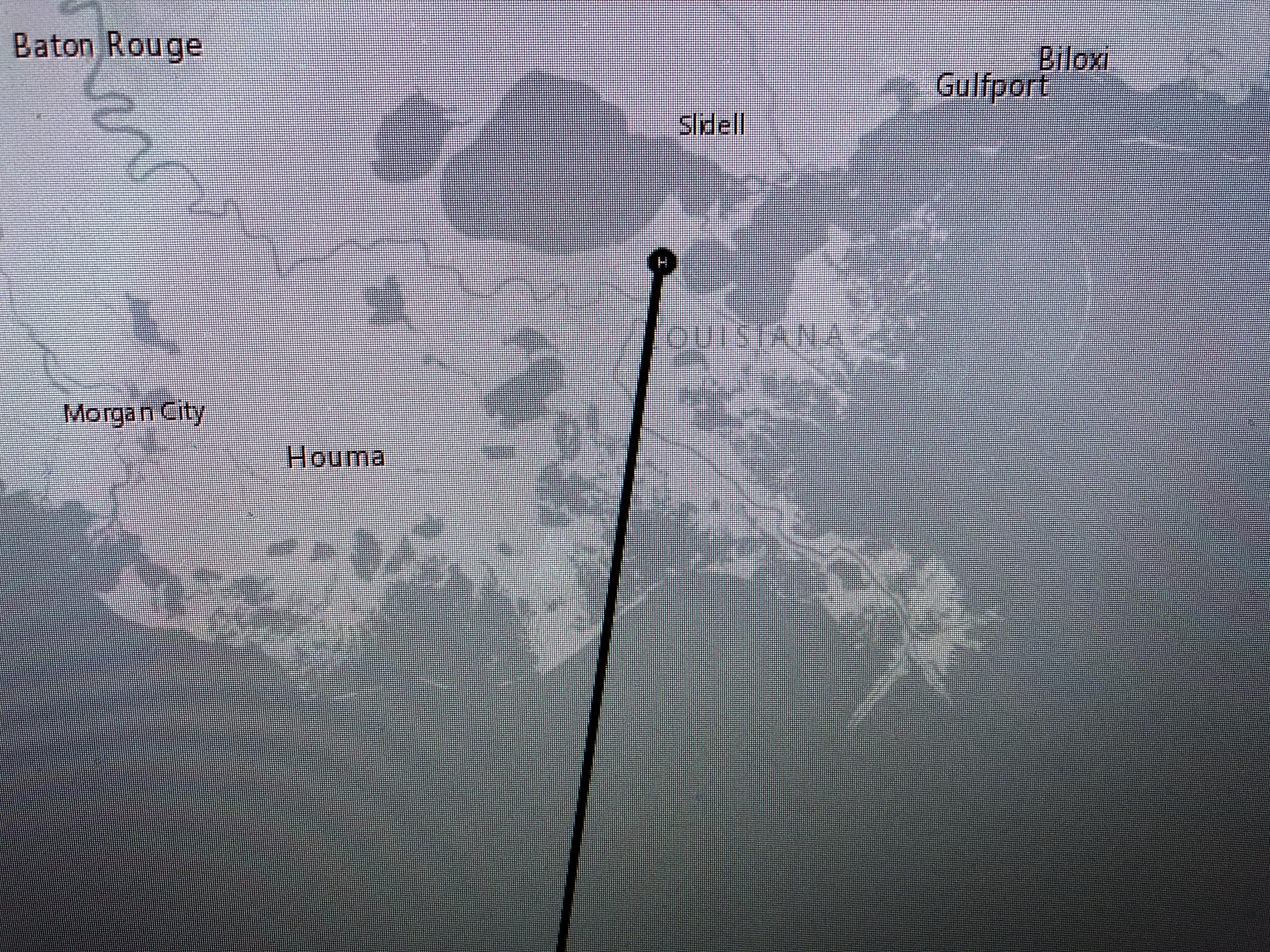
If you're watching a station that doesn't use the center line track, you wouldn't know or see this subtle shift to the west. The top graphic was NHC's 1st advisory taking it just east of the CBD and Lake Pontchartrain with the 2nd about the same. But then this morning and afternoon's tracks slightly move it farther to the west now coming over Morgan City and west of Lake P. I don't want that to happen since that places us on the stronger side/greater impacts of Delta. The Euro model has it even farther west over Lafayette. Delta won't reach the Gulf until late Tuesday night and once it's clear of the Yucatan, I think models will really lock on to that future path. Before then, what could happen?


Will the remains of Gamma (now a TD) have any influence? The current forward motion is west at 8 mph and that could take Delta on the western side of the error cone into the Yucatan, which would impact its circulation. Let's watch that forward motion for the next 24 hours. For now, NHC keeps it over water through the Yucatan Channel. This track is not much different than Hurricane Lili in early October 2002. It became a powerful Cat. 4 down over the Gulf, but rapidly weakened as in approached the LA. coast making landfall as a Cat. 1. That's my hope for Delta, or, we start to see model shifts taking the storm back to the east so we get on the weaker side of the storm.
Speaking of that cone of error, it extends from Beaumont in Texas to Pensacola, Florida. IF you can avoid the eye wall winds & storm surge, impacts from a Cat. 1 or 2 will not require any evacuations except outside of our levee protection/risk reduction system. I'm sure local emergency managers will start that process once Delta reaches the Gulf late tomorrow. I'm confident the cooler northern Gulf will work its magic on Delta just like it did with Lili back in 2002. Next post after 10 PM. Stay tuned!


21 comments:
Thanks for the update! I really appreciate your blog. :)
Thanks Bob 😊
Thanks for staying in top of these storms! I trust your forecast more than any other.
Thank u Bob... Let's all pray...
That can be scary for some. I live in Montegut where for Lili a wall of water that resembled that of a cst 4, poured over the levee system and left behind more water in this area than that of Hurricane Andrew and Juan. I hope you are right but those little reminders of storms past tell us to stay prepared.
It seems like that there's a definite trend of the models shifting to the west more and more.
Really appreciate your blog..it’s the best
4840 is the score to beat
thanks for the info Bob , the Fat Lady has sung!
I hope that everyone has their hurricane kit ready. In mine, I have a flashlight, lucky bean, St. Jude holy card, carton of GPC cigarettes, jumbo pack of Freedent gum, Vienna sausages, Glade air freshner, weather radio, fifth of Old Crow, batteries, Hormel chili, and playing cards.
If Delta ever becomes a cat3 with New Orleans in the cone that triggers a mandatory evacuation order? Would the order stay if the storm then weakened below a 3?
The only thing missing is some of that St. Joseph altar bread from the freezer 😅
This is my prediction... I have never been wrong. The storm is going to strengthen to a category 3-4 practically over night and depending on how fast this high pressure system moves away from us is going to determine how far of a turn East this hurricane makes. If this high pressure system moves away quickly, we are going to get the strongest eastern part of this hurricane. If it moves away slowly, we are going to still get a very strong beating from this hurricane but not as bad as it could be. From what I can tell, this high pressure system will be gone by Wednesday which is bad news for us. If this warm weather can stay away until Thursday, we will be fine, but if it’s warm Wednesday back into the mid 80’s, we are going to get crushed.
Sleep well, little Tater Head!
This is my prediction..."Harry" and his never-wrong prediction will be no where to be found in a few days, after he's wrong.
Lol
Harry, if you've never been wrong, what the heck are you doing sowing your wisdom on someone else's blog instead of achieving fame and stardom as the world's greatest meteorologist/psychic?
Just sayin'. I find that "never wrong" claim absolutely impossible to believe.
Happy Birthday Bob!
Thank you Bob, HAPPY BIRTHDAY!!!
Thanks, Bob
So far how am I doing on my “never wrong” claim!
Post a Comment