Before you start running for the Valium, take a deep breath and let's go over the details. Since the storm has little forward motion, that should allow a deep upper trough now over the Rockies to increase the SW upper shear over the northern Gulf as Zeta moves toward us. That should turn the system to the right of us. Zeta is not forecasted to reach the Gulf until Tuesday morning.
Having said that, NHC has made a 50-60 mile shift back to the west in their center line track.
The top pic was this morning's track forecast with the bottom the current one. That's a pretty significant shift based on little movement in today's forward motion. I wouldn't get too concerned unless this westward shift continues for the next 2 days..
Looking at NHC's wind forecast and you kind of see the main channel RIGHT NOW crosses lower Plaquemines Parish aiming for the MS/AL coasts. As mentioned in previous posts, this will not be a Sally strength storm based on cooler water temps and increasing wind shear that should weaken Zeta as she approaches the coast.
The bottom line is stay left (west) of the center line and you won't get much of anything with the upper SW shear making this a east weighted storm. That is why I focus so much on that center line.Satellite views show Zeta has most of the convection/storms on the southern side. Surface pressures have lowered indicating a strengthening storm and NHC makes it a hurricane on Monday. It could even make a Cat. 2 before it heads farther into the Gulf. Obviously we'll update again tonight after 10 pm.
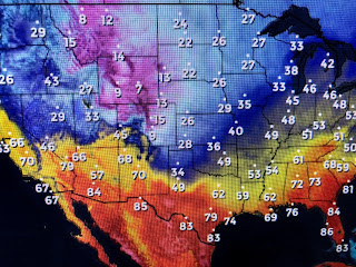
We were lucky to break out into sunshine that made for a lovely Sunday. Much of our nation was not so lucky as clouds covered coast to coast.
The snow storm coming out of the Rockies will bring us our next front on Thursday. Even some sprinkles are falling in southern California.


12 comments:
Was there really a reason for the National Hurricane Center changing the forecast track and by so much (the official discussion said that the track was very similar to the previous one)?
Bob doesn't have much of a clue, he just said Thursday this storm IF it developed would turn east and go over Florida...
People who run for Valium because of a hurricane or a tropical storm should seek psychiatric help. The most exciting time of the year should be hurricane season especially August and September. They should welcome hurricanes with open arms.
Hurricane Lover
I see it's avoiding the speed trap in Golden Meadow. It makes a quick trun to the east before it get to G.M. corporation.
Anonymous......you're an idiot
Du bist verrückt.
Du bist verrückt.
Du bist verrückt.
Three copies. I don’t know why it does that.
Haha. Golden meadow gonna get wet. Speed trap and all.
The Zeta link on the tropical storm page may not be active. Nothing happens when I click on it
Thanks for the feedback Doc. Only the Z in Zeta was linked. We have now fixed it.
Post a Comment