As Coach P. admitted, we didn't do a good job AND that includes COACHING. Duh! We watched Jalen Hurts do that for 3+ years at Alabama & Oklahoma. What were they expecting? We looked clueless & that goes back to poor coaching. Nuff said.
Today's models are continuing the trend for a colder last 2 weeks in December. The current upper air pattern has a digging trough coming into the Rockies that will bring us another cold front on Wednesday and an East Coast snowstorm on Thursday.
The top graphic is current with the arrow pointing out the upper low. The bottom graphic is the upper flow on Christmas Eve. Notice how the trough has shifted a little to the west and deepened. That should bring down the Arctic air from Canada, and there's plenty of it.
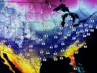
Single digit temps have pushed into the lower 48 and, as the upper low comes out of the Rockies, the stage is set for 1-2 FEET!!! of the white stuff over parts of the Northeast. it should be exciting to watch later this week.
The top view is the water vapor with the arrow pointing to the upper low. The bottom is the visible satellite channel that has lots of clouds over much of the nation.
You can see how the current cold air has plunged deep into the Gulf with a band of lingering clouds over us keeping it rather chilly. We should clear later tonight and see some morning sun on Tuesday before clouds come back ahead of the next front on Wednesday.


No comments:
Post a Comment