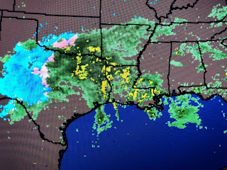
The top graphic is the current Tornado Watch with the middle showing the warning just outside the watch area. The bottom is an area SPC has highlighted for the possibility of another watch, but they say that shouldn't happen before 6-7 PM. Current radar views confirm the heavier storms remain to our west.
On the west side of the surface low, temperatures are cold enough to produce heavy snows (6"+) closing down parts of I-20.
There is a sharp temperature decline behind the cold front, but the air is not coming down from the Arctic. The real issue is the high dew points (65-70) that indicate low level moisture has surge northward off the Gulf. Until we can get the cold front through later tonight, we'll be in the warm air sector that will keep us in the severe weather threat.
The top two satellite views show a complex upper pattern with 2 upper swirls that are rotating around a large trough over the Rockies. The bottom 2 views point our the surface features. Of note is the brighter clouds showing up SE of the mouth of the river. Fortunately for SE LA., the bulk of those storms should move east of NOLA. However, we'll need to pay attention for the next several hours until the cooler air arrives after 9 PM.
Finally, in my previous post, I said we should stay dry through 4 PM. WRONG! I made the post around 11 AM . Look at the time stamp on the radar views. From just a few showers offshore south of Port Fourchon, the radar returns exploded with heavy downpours reaching the city just after noon. That's why we can't just blow off this evening's severe threat until the cold front arrives.


1 comment:
Bob, did the SPC and NWS overcook their severe weather predictions for NYE, especially for the metro area? We had some rain and some not so high winds but nothing in the way of what we got on Nov. 25, 2020.
Post a Comment