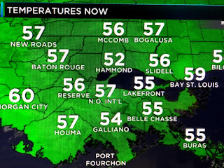
As the surface high pulls away, winds will turn more southerly and that will bring back the low level moisture/clouds ahead of our next cold front.
Note the 70 degree warmth over south Texas and we'll rebound into the 65-70 degree range tomorrow. Clouds will increase during the day but the rain should hold off until after dark.
Zack has most of the rain moving through between 4 PM & midnight with cooler air (not colder) coming back on Sunday. Christmas week should start mild, however, a big East coast trough will trigger a major storm over the eastern states with an Arctic outbreak coming here for Christmas Eve & Day.
The top graphic is the current upper flow with the middle being the forecast for Christmas Day. IF that proves accurate, look at how cold the air is over central Canada (30-40 below). Timing will be crucial
but it looks like any snow threat will stay to our north and east. Still, highs in the 40s will certainly make us feel like Christmas. Things could change, but I'll be focusing not on snow here, but on the potential of a hard freeze for Christmas Morning & night. Stay tuned!


No comments:
Post a Comment