Yesterday's Midwest snowstorm has shifted to the East Coast where a developing Nor'easter is shutting down air and auto traffic. The worst is yet to come for cities east of NYC and Boston is just beginning to get into the snow.
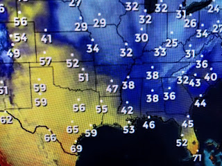
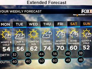
As the Nor'easter grows stronger tonight, the circulation is driving down some chilly air all the way down into the Gulf and south of Miami. This is very dry air that will feel refreshing IF you're dressed for it. A warm up will begin in earnest on Wednesday with our highs back 70+ by Thursday. But before then, the next 2 nights will be chilly.
The main issue tonight will be the wind chill as winds are not likely to lower until during the day on Tuesday. Heavy coats will be required as it'll feel like the 30s later tonight.
With the current wind speeds, there should not be a big "Lake effect" tonight as the air won't be over Lake P. long enough to moderate any. With less winds tomorrow night, I expect lows to be colder. Still, it's next week that looks to be colder than our current cool snap. Get ready Gang. We could be cold enough for snow. We just need a Gulf low to develop and then...Buda Bing, O so pretty! Stay tuned!


No comments:
Post a Comment