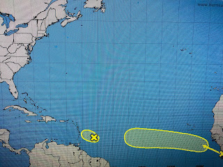
Even the area near the Islands has become better looking, although NHC keeps chances for development at 10%. The other two systems in the Gulf from my earlier post have done little.
The one over south Texas has moved westward onto land while the one off Tampa/St. Pete is still there, but it has no weather with it. Locally, it was another day of active showers & T-Storms.
The weak frontal boundary stalled before reaching us and is now retreating back to the north as a warm front. You can clearly see the difference in airmasses as dew points north of the boundary are in the 50s & 60s (Little Rock, Memphis Nashville, Atlanta) while they are soupy (low to mid 70s) south of the front. Such high dew points indicate abundant low level moisture is available resulting in very efficient rain makers.
The 7 day forecast has rain each day and it's difficult tp single out which days will have the higher rain chances. A Tropical Wave will approach us from the SE on Sunday increasing our rain chances lasting into Monday. Bottom line, this is Summer in the South and if there isn't an upper high to suppress our daily showers, you need to keep the umbrellas nearby. Stay tuned!


No comments:
Post a Comment