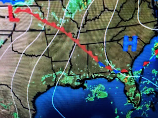
My long time friend and competitor Dan Milham coined a acronym back in the 80s that he called the M.O.T.S forecast. It stood for More Of The Same and can often be used from mid June into September. Fronts stop coming so the only way we see a difference in our daily shower pattern is 1) a tropical system approaches or 2) an upper air disturbance enhances our clouds and shower coverage. The Tropics remain quiet this week as I can only find 2 swirls on this afternoon's satellite views.
NHC thinks the system coming off of Africa has the better (40%) chance for development and that is so far away that I don't want to fool with it yet. Closer in, there are lots of clouds around an old frontal boundary that extends from Texas eastward out into the Atlantic.
As with most summer T-Storms, lightning is always a danger. In addition, we are in a slow moving environment when storms that linger for 1-2 hours can quickly produce street flooding.
the storms along the Gulf coast and over Florida are providing some relief from the heat. However, look at the 70+ dew points surging all the way into Iowa. They are feeling our kind of humidity. Locally, slow moving storms have cooled off some spots, but not everyone.
So the MOTS forecast will continue into Sunday when a weak tropical wave could increase our clouds and showers. If you work or play outside at this time of the year, you must stay hydrated so you don't suffer heat exhaustion or heat stroke. Common sense Gang. Stay tuned!


No comments:
Post a Comment