Satellite views indicate clouds are draped back in from the Atlantic along an old frontal boundary. The western end over the Gulf has the broad circulation where I find at least 3 smaller swirls rotating around the broad center. All of the T-Storms are well east of these centers and I would be surprised if NHC makes this a TD until it tightens up some more.
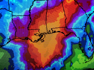
The Weather Prediction Center has much of SE LA/MS in the moderate risk level for heavy rainfall for tomorrow and Saturday. However, I noticed they has shifted the center of heaviest rainfall eastward this afternoon. My take is any shift farther to the east would mean will will not see the really heavy (5-10") totals, but more in the 1-3" amounts at worst. Here's what I'll be watching.
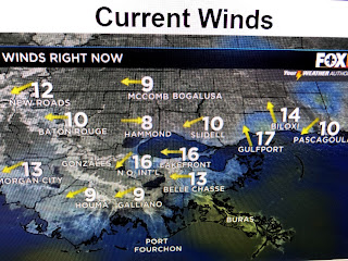
WIND DIRECTION. IF a closed center forms and moves to our west playing us on the "wet side" of this system, our surface winds will turn from the ENE to SSE tonight and Friday. IF our winds stay NE to N, that would mean the center is going to our east and we would see very little from whatever forms. NHC will either issue advisories at 4 PM or wait until later tonight. Right now, there is an upper low over the western Gulf creating a somewhat hostile environment. I'll post again after we get all the data from the Hurricane Hunter aircraft probably before 5 PM. IF you are going to the Gulf Coast beaches for Father's Day weekend. just know Saturday looks wet and there will be high danger of rip currents through the weekend. Stay tuned!


No comments:
Post a Comment