If you can believe the models, a real change is coming for later this week.
These graphics are the upper air flow at 500 mb (18,000') for the next several days. The top is from this morning showing the trough over the SE that will slowly work to the west by Thursday (middle graphic). The bottom view is valid for Friday morning with an upper high building over us. that should result in no rain and hotter temps as the extended shows.
The bottom graohic has this afternoon's placement of the Atlantic Ridge well down over the southern Gulf with lots of unsettled weather over the northern Gulf. That will all change as we head into this Tarpon Rodeo Weekend.
You still have the opportunity to register to win a chance at a fully equipped Bay Boat & trailer even if you can't fish this weekend. Just Google Tarponrodeo.org or go to Chag's or Puglia's in Metairie or the many outlets on the way down to Grand Isle & register.
The Tropics remain quiet & the models say it will stay that way into August. We just need to get this frontal boundary outa here so we can dry out. That is coming for later this week into next week.
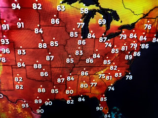
This has not been a super hot summer in the east as the rains & clouds have keep temps below normal/average. The West continues to bake, although there have been some storms bring welcome rains to Arizona, Utah & Colorado.


1 comment:
Your grandson is adorable. Thanks for sharing.
Post a Comment