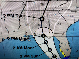
The top graphic has the past track (blue line) that veered into Cuba this morning. That shift in direction forced NHC to shift their forecast farther westward. I have been showing you that trend for 2 days.
You can clearly see the shift of the center line over the past 24 hours. The top graphic had Fred going east of Apalachicola with the middle right over AAF and now the current one much farther to the west. If you're just looking at the cone, you would not have noticed that shift.
If you look at the tighter view, the center line is between Destin & Seagrove Beach. That will bring a dramatic end to their sunny, hot & dry weather. Saturday looks fine into Sunday, but Monday turns rainy that may linger into Tuesday. Fred still will have the opportunity to regain some strength over the NE Gulf, and NHC has it back up to a 60 mph Tropical Storm.
With all the T-Storms forming over Cuba during daytime heating, it's hard to find where Fred is located. As you can see, Fred isn't the only player on the map as we have a tropical wave moving north of the Islands and newly named Tropical Depression # 7 which will be named T.S, Grace tonight or tomorrow. The NHC track for soon to be Grace is similar to Fred's.
For now, it appears neither Fred or Grace will have any impacts for us. However, if you're heading to Florida's beaches, just know some heavy rainfall is expected along with gusty winds to 50+ mph.
IF the new westward track proves correct, the heaviest rains should stay away from the major theme parks. Since we'll be on the sry side of Fred, we actually could see our rain chances decrease for Sunday & Monday. What we don't want to see in the Gulf or Caribbean is what's happening in the Pacific.
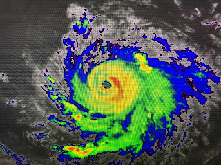
Linda has become a major Cat. 3 hurricane with winds 115+. So far, the systems in our part of the World have been much weaker. Even soon to be Grace is not predicted to become a hurricane since it's expected to have too much land interaction.


1 comment:
Thanks, Bob. I always enjoy your analyses.
Post a Comment