It appears most of tonight will stay dry, but with the center of Nicholas stalled over SW LA. storms could redevelop later tonight offshore and move inland before daybreak.
The top photo showed the sunny breaks from this afternoon with the second placing where what's left of Nicholas is still spinning. Like Harvey in 2017, he stalled, but unlike Harvey, Nicholas never had the well defined structure of a major hurricane so 2 day rain totals have been generally 3-4" with some totals up to 8". The color pic has the boundary just off the mouth of the River that extends down to the SW. That's where we have to watch for redevelopment late tonight & on Thursday. So why is Nicholas stalled?
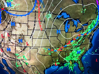
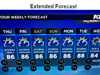
His circulation has been left behind as you can see on the surface map, the Bermuda high, that steers storms around it, has backed off into the Atlantic while a cold front has become stationary over the Ohio Valley. You can see another front up over Montana and that might get here by Wednesday of next week. Until then, the 7 day is pretty useless as nothing will be changing. Look for above normal clouds, many shower periods with heavy downpours, but some dry hours. No real cool relief until October. Stay Tuned!


2 comments:
You're the best this is great
You're the best thanks this is awesome
Post a Comment